The
Death Ride Plus
..
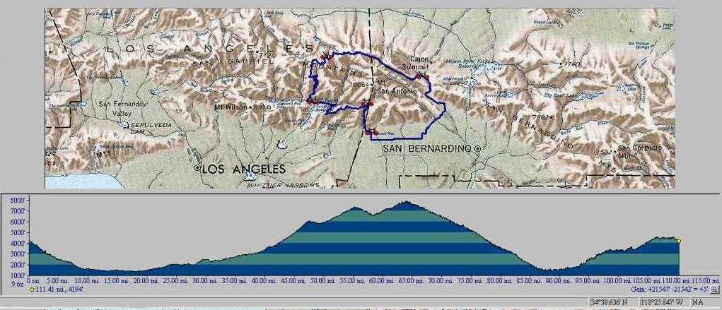
112 mi. and 10,773' of climbing in the San Gabriel Mountains
By Ray K
Ride Description... CCW
A loop around the highpoint of the San
Gabriel range, Mt San Antonio.
Starting and ending in the Mt Baldy Village,
@4200'. It is a fast drop down to the bottom of
the hill to Baseline in Upland
where you go
east until you reach
Lytle Creek cutoff. Here you continue east toward Glen Helen, and
then
north through Devore, west to old Route 66, and north through Cajon
Pass
to Hwy 138.
Here you turn west and head up the San Andreas Rift Zone, up Lone Pine
Canyon
to Wrightwood, about 9% grade a good
climb, and you are back in the high country,
6000' and climbing
through Big Pine, Grassy Hollow, Vincent Gap, to a highpoint of 7901'
at the Dawson Saddle. From here
you won't have to pedal
for 22 miles! It's all down hill to the bottom of
Azusa canyon.
Continuing from Dawson Saddle on Hwy 2 until you reach
Islip Saddle and a left turn down the gated Hwy 39 cutoff toward
Crystal Lake, and down Azusa Canyon.
When you reach the junction of Hwy 39 & the East
Fork Bridge, go east across the San Gabriel River, then
up the
East Fork a few miles to Camp Williams Cafe.
a good place to rest and
refresh before the last two climbs 6% and 6.3% respectivly.
The first from the canyon floor to
Glendora Ridge Road , and second along the ridge road up 'Reward' the
last 3.5 mile climb before the Mt Baldy Village.
Home at last!
============================
Ride Description... CW
The
Ride starts and ends in the Mt Baldy Village where the Glendora
Ridge
Road meets the Mt Baldy Road. The first climb, a short .9 mi.
warmup out of the Mt Baldy Village.
Then a few mi. of easy spinning
flat, to a 3.5 mile downhill to another 4.54 mi. of
rolling hills to
the East Fork cutoff. and down to the East
Fork of the San Gabriel River. The ride continues slightly
down hill
along
the canyon bottom about 4 miles through picnic areas, Camp
Williams,
Fellows Camp and to the bridge that crosses the top of the San Gabriel
Reservoir where it meets Hwy 39.
Now a 27 mile climb up
Hwy 39 through Crystal Lake area and on to Hwy 2 at
Islip Saddle 6,600', to Dawson Saddle 7901'
(the high point).
Continuning to Vincent Gap 6,593', - Grassy Hollow, - Big Pine, -
Wrightwood, - Lone Pine Cyn, - Cajon, - Devore, - Etiwanda, - Alta
Loma,
and to the top of Euclid Ave.,and the climb back up to the Baldy
Village..
The total is 112 miles.
From Baldy to Hwy 39 is mostly downhill 21 mi.
The major climb is from mile 21, the East Fork Bridge at Hwy 39, to
Dawson Saddle, mile 48. This is 27 mi. of climbing 6,500+', in
the first half of the ride.
Big Pine to Etiwanda is mostly downhill 40 mi.
Lone Pine Canyon downhill, a 8 mile straightaway, it is easy to
reach 55+ !
There are restraunts at Mt Baldy Village, and Camp Williams before the
climb and in Wrightwood and beyond on way down.
A must in your bag of bike riding experiences!
Yahooee! Ride your Bike!
Raymond
Click on the picture above for a more detailed view
Return