|
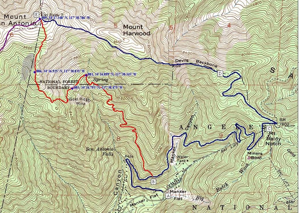
To the Summit - Via Baldy Bowl Blue trail A to B = .91miles and Red trail B to E = 3.20 miles San Antonio Falls, Sierra club, Baldy Bowl, and ridge to the summit This is a strenuous climb to the Summit, but the shortest F6F Hellcat wreckage can be viewed and accessed from this trail. 6156' to 10,064' 3,908' vertical 4.11 miles = 951' per mile The gray colored area is the debris field from the wreckage of 2 F6F Hellcats. The hellcats crashed on March 2, 1949 see: http://www.av.qnet.com/~carcomm/wreck21.htm |
Waypoints
001- N34 16.899 W117 38.343 Is at the Y in trail to Sierra club Hut ( The hut is about 150' from this waypoint) 003- N34 16.793 W117 38.475 Is a Large boulder (I call it 'House Rock') it is great for rock climbing, and has bolt hangers on top for protection ropes. 009- N34 17.348 W117 38.786 Is the Mt Baldy 10,064 Summit Marker 006- N34 16.925 W117 38.835 From this location standing on top of the precipice looking West toward the bottom of the canyon, you can see the empennage of one of the F6F Hellcats. |
| To the Summit - Via Ski Lifts Blue trail A to E - falls Rd via Baldy Notch, Devils Backbone to Summit This is the easiest way to the summit 6156' to 10,064' 3,908' vertical 6.2 miles = 630' per mile |
A to C Falls rd to Baldy Notch (This section can be bypassed by riding the Ski Lifts to Notch) 6156' to 7750' 1594 vertical 3.17 miles C to D Notch to top of lift 4 7750' to 8533' 783 vertical 1.26 miles D to E Top of lift 4 to Summit 8533' to 10,064' 1531 vertical 1.77 miles |